
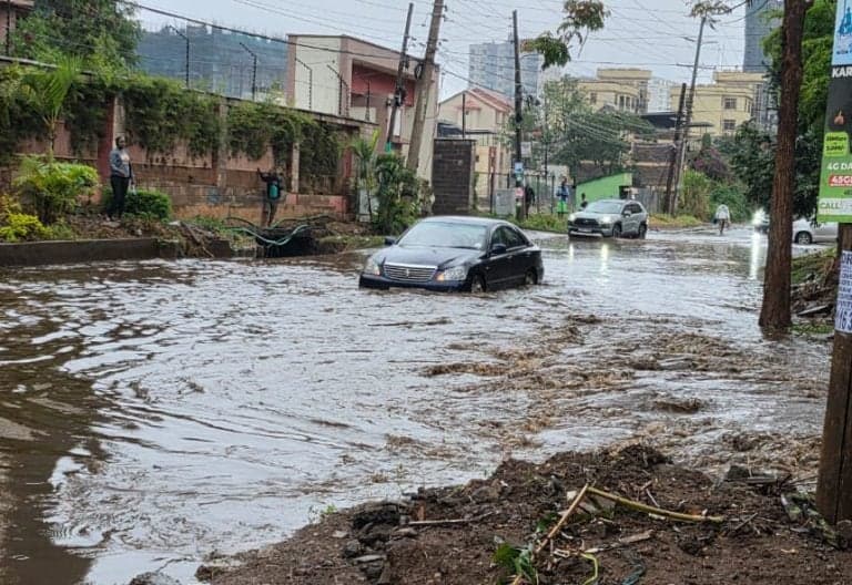
No. El Nino did not start in Nairobi on Saturday morning.
El Nino is not a Nairobi rainstorm. It is the warming of the sea surface in the central and eastern equatorial Pacific Ocean, which shifts winds, pressure and rainfall patterns around the world. By that measure, El Nino was already established long before this weekend — and the rain that flooded Nairobi roads overnight is better understood as the uneven, delayed arrival of Kenya's October-December short rains, in a season forecast to be wetter than normal partly because of El Nino. Rain in Nairobi, on its own, does not prove El Nino has started. El Nino only tilts the odds.
The global position is unusually blunt. In its monthly Global Seasonal Climate Update on 8 October 2026, the World Meteorological Organization (WMO) said: "El Nino is firmly established and strengthening rapidly. WMO forecasts indicate a near-100 per cent likelihood that it will persist through February 2027, potentially being one of the strongest since at least 1950." The WMO said the widely used Nino 3.4 index — the sea-surface temperature anomaly in the central-eastern equatorial Pacific — rose from an average of 1.6 degrees Celsius above normal in June 2026 to 2.5 degrees above normal in August, and is forecast to reach about 3.7 degrees above normal for October-December, peaking around December. That would be higher than the previous record of 2.6 degrees in November 2015 to January 2016, if it is realised. The forecast is a consensus across 13 national and international centres. A separate WMO update in September had already put the likelihood of El Nino persisting through September-November 2026 and December 2026-February 2027 at nearly 100 per cent.
The regional picture points the same way. The IGAD Climate Prediction and Applications Centre (ICPAC), at the 74th Greater Horn of Africa Climate Outlook Forum in Kigali on 17-18 August 2026, forecast wetter-than-normal October-December conditions across much of the Greater Horn, driven by the strengthening El Nino alongside an emerging positive Indian Ocean Dipole. ICPAC put better than 90 per cent odds on rainfall exceeding 400mm over the season in parts of central Kenya, the Lake Victoria basin, central and southern Somalia, Burundi, and western Rwanda and Tanzania. On 6 October 2026, the Famine Early Warning Systems Network (FEWS NET) said in a special report that the 2026-2027 El Nino had strengthened to "very strong" levels, and that El Nino combined with a positive Indian Ocean Dipole was forecast to bring above-average rainfall across the Greater Horn during October-December, with historical comparisons suggesting rainfall could reach 150 per cent of average or more in many areas. FEWS NET also warned that strong El Nino events typically bring heavy rainfall and flooding in the eastern Horn, even as above-average rain helps crops, pasture and water availability.
Kenya's own seasonal outlook said the same, in Kenyan terms. On 26 August 2026, the Kenya Meteorological Department said above-average rainfall was expected over 80 per cent of the country in the October-December 2026 short-rains season, with prolonged wet spells and occasional isolated storms, and that the 2026 El Nino event "continues to intensify across the central-eastern equatorial Pacific", with a weekly Nino 3.4 index of +2.7 degrees Celsius in mid-August, "evolving toward a very strong event". For Nairobi and the Central Highlands, onset was put in the second to fourth week of October, with rains continuing into January 2027. Kenya Met's October monthly bulletin, dated 5 October, repeated that above-average rainfall was expected over Nairobi and neighbouring counties. But every one of these outlooks is a seasonal probability, not a promise that every county gets heavy rain on the same day. Kenya Met and ICPAC both cautioned that El Nino strength alone does not determine how much rain any one place receives — the Indian Ocean Dipole, the movement of the rain-bearing Intertropical Convergence Zone (ITCZ), and local drainage all matter.
That is why Nairobi's October felt confusing. Kenya Met's Director of Public Weather Services, Hannah Kimani, told a local station on 21 October that low-pressure systems over the northern Indian Ocean had temporarily slowed the southward movement of the ITCZ, disrupting the expected spread of rain. Some areas — Mandera, Marsabit, Nyeri and Meru were named — had recorded onset as expected, while central and eastern Kenya waited. Kenya Met maintained on 30 October that the delay did not change the seasonal outlook, and warned against reading isolated showers as the formal start of the season. In the 24 hours to 9am on 30 October, Kenya Met's own station totals underlined how patchy it was: Matungu recorded about 77mm, Iranda about 50mm, Masii about 44mm and Kathonzweni about 40mm, while Nairobi stations at JKIA, Wilson Airport and Eastleigh registered only minor amounts.
The heavy-rainfall advisory that covered the peak of that week has now expired. The advisory issued on 23 October warned of moderate to heavy rainfall exceeding 20mm in 24 hours in parts of the Coast, the Northeast, the Highlands, the Central Highlands and the Southeastern Lowlands, including parts of Nairobi, with intensity expected to peak between 26 and 29 October and decrease by 30 October. It was valid from 18:00 on 24 October until 09:00 on 30 October. No replacement multi-day heavy-rainfall advisory dated 29-31 October was found in the searches checked for this article. What replaced it was the routine daily and five-day forecasting: Kenya Met's daily forecast issued on Friday 30 October put rain in 44 counties on Saturday 31 October, with only Mandera, Turkana and Marsabit expected to stay dry, and thunderstorms in 32 counties, mainly in the afternoon. For Nairobi it forecast sunny intervals with rain in a few places in the morning, then light showers and thunderstorms in a few places in the afternoon, with temperatures of 17 to 28 degrees Celsius. The five-day forecast for 31 October to 4 November, issued on 29 October, forecast moderate afternoon showers in Nairobi on Saturday (moderate meaning 5mm to 20mm in 24 hours), light showers on Sunday 1 November, sunny intervals on Monday 2 November, and light showers on Tuesday 3 and Wednesday 4 November, with temperatures of 14 to 30 degrees.
Citizen Digital reported that Kenya Met's 24-hour rainfall forecast valid from 09:00 on Friday 30 October to 09:00 on Saturday 31 October projected most of Nairobi County at 5mm to 20mm, with isolated places likely to record more than 20mm, plus isolated thunderstorms. That overnight rain is what Nairobi woke up to.
First Avenue in Parklands flooded near Oshwal School after the morning showers on Saturday 31 October, People Daily reported at 09:59 EAT, using a photograph shared by the Parklands Residents Association (@parklandspamoja on X) showing vehicles driving through the waterlogged road. The association's own wording is the most useful correction in the whole morning. It did not say El Nino had arrived. It said: "And boom 1st Avenue at Oshwal school has flooded with just a drop of downpour. Now imagine the real full-blown El Nino coming our way." In other words, residents were warning that a small amount of rain had already overwhelmed the road, before the heavier, prolonged rains forecast for later in the season.
Githurai Roundabout flooded after a heavy overnight downpour, People Daily reported at 11:59 EAT, with people stranded and motorists and pedestrians struggling through the busy route, using a photograph credited to @Young_Pharmacie on X. On Waiyaki Way in Westlands, a City Shuttle bus got stuck in a ditch after the heavy rainfall, according to reporting by The Kenya Times and Uzalendo News. No injuries or deaths in these three Nairobi incidents were reported in the reports checked for this article, and no campus closure or campus flooding on 30-31 October was found in the searches checked. Students should not confuse this weekend with the March 2026 floods, when University of Nairobi hostels were flooded and people died across the country — that was a different season, the long rains, and it is not this story.
Social media split exactly along the question this article is asking. Kenya Gossip Club shared a Facebook post on 31 October at 06:09 UTC (09:09 EAT), with 3,400 likes and 63 comments at the time it was seen, headlining the Nairobi flooding and questioning whether it was El Nino, using a grid of flooded-street stills and an overlaid post by Bravin Yuri (@BravinYuri) asking: "So, are we saying this isn't El Nino?" The post itself was not read directly on X — it was seen only as a screenshot inside that collage — so Campus Pulse is not quoting a verified X URL here. Commenters under the post were split between accepting the rains as El Nino and dismissing them as ordinary weather made worse by poor drainage, with some blaming litter and blocked drains and others expressing relief at water access. A separate Instagram reel by Vibes TV Kenya (@vibestvke) on 31 October, with on-screen text reading "RIVERS Overflow as El Nino Hits Nairobi", shows a brown, fast-flowing river overflowing its banks, but the summary seen does not name the river or the exact location, and the reel's caption asserts El Nino rather than evidencing it. It is reported here as a social post making that claim, not as proof of it. On Facebook, a widely shared photograph of a flooded street under an overpass drew comments including "Mvua kidogo drainage issues! So what happens when the real Elnino starts?" — again framing Saturday as a warning, not the peak — alongside a commenter disputing the scene from Githurai itself. Scepticism was already high before the weekend: under a TUKO forecast post on 30 October, commenters mocked the forecast after the dry spell, joking about "El Nino ya 10 minutes" and a "sun El Nino", and debating whether El Nino had arrived at all.
The preparedness question is real, and it is separate from whether El Nino has "started". Governor Johnson Sakaja said on 12 October that Nairobi County had identified 227 flood-prone hotspots across the capital's 17 sub-counties, that about 100,000 residents could face potential displacement under a worst-case flooding scenario, and that 26 of 61 critical drainage sites had been cleared, with river desilting, removal of obstructions and opening of waterways under way. People Daily also reported demolitions along 1st Parklands Avenue, where houses and perimeter walls obstructing a river had been brought down, and drainage works in Westlands including Woodvale Grove, Mpaka Road and First Parklands. The county said it had activated an Emergency Operations Centre and a public hotline, 1508. The Kenya Times reported Governor Sakaja outlining a KSh 10 billion flood mitigation programme; that figure is as reported by that outlet and is not confirmed here as money spent. Nationally, the government directed all 47 counties to identify flood-prone areas, establish evacuation grounds and strengthen emergency response, and the Ministry of Health warned that flooding could contaminate water sources and increase cholera, typhoid and malaria risk. None of that is evidence about Pacific sea temperatures. It is evidence that Nairobi's drains, rivers and roads are the part of this story residents actually live with.
For students, the practical point is narrow. Classes in public universities are due to resume on Monday 2 November after the lecturers' strike was called off (see Campus Pulse article 34), and Kenya Met's five-day forecast has Monday in Nairobi as sunny intervals, with light showers returning on Tuesday and Wednesday afternoons. That is a forecast, not a guarantee, and the weekend showed how quickly a road can flood after one night of rain. Do not walk or drive through flooded roads, rivers or bridges, Kenya Met has repeatedly advised, and check the daily forecast and your own university's notice before travelling.
So: has El Nino started in Nairobi? The wrong question, answered straight. El Nino started in the Pacific months ago, is firmly established and strengthening, and is forecast to peak around December and persist into February 2027. Nairobi's short rains have started unevenly, after a delay, and Saturday's flooding shows what even a moderate night of rain does to roads with poor drainage. The heavy, prolonged El Nino-influenced rains that the seasonal forecast warns about are still, on the forecasters' own timetable, to come.
What we could not verify: a replacement heavy-rainfall advisory dated 29-31 October 2026 (none was found in searches; the 23 October advisory expired at 09:00 on 30 October); the actual rainfall totals recorded in Nairobi for the night of 30-31 October by station (the forecast was 5-20mm for most of the county, with isolated places over 20mm, but station totals for that night were not in the reports checked); the original X post URLs for the Parklands, Githurai and Bravin Yuri posts (seen only via People Daily credits and Facebook collage screenshots); the exact river and location in the Vibes TV Kenya reel; any campus-specific flooding or closure on 30-31 October; and whether the KSh 10 billion Nairobi flood programme figure represents approved, allocated or spent money. The WMO figures above are as reported from its 8 October update via multiple secondary reports; the original WMO release text was not opened directly for this draft. No rainfall figure, injury, or campus impact has been invented for this article.
SOURCES:
- WMO Global Seasonal Climate Update, 8 Oct 2026, as reported by Phys.org, ETV Bharat, The Hindu BusinessLine and Geo TV (firmly established and strengthening rapidly; near-100% likelihood of persisting through Feb 2027; Nino 3.4 +1.6C June to +2.5C Aug, forecast about +3.7C Oct-Dec peaking Dec; previous record +2.6C Nov 2015-Jan 2016): https://phys.org/news/2026-10-sea-surface-temperatures-el-nio.html and https://www.geo.tv/latest/685560-el-nino-will-intensify-then-peak-in-december-un
- WMO El Nino/La Nina Update, September 2026, as reported 18 Oct 2026 (nearly 100% likelihood El Nino persists through Sep-Nov 2026 and Dec 2026-Feb 2027; weekly relative Nino 3.4 +2.81C for week ending 11 Oct 2026): https://www.unilad.com/news/world-news/el-nino-peak-expected-experts-warning-strengthening-443150-20261018
- ICPAC GHACOF74, Kigali, 17-18 Aug 2026, as reported by Uganda Radio Network and VISO Uganda (wetter-than-normal Oct-Dec; >90% odds of >400mm in parts of central Kenya, Lake Victoria basin and others; 1997 and 2023 analogues; 95% probability strong or very strong by end of 2026): https://ugandaradionetwork.net/a/story/strong-el-nio-raises-flood-and-food-security-risks-across-igad-region-
- FEWS NET Special Report, 6 Oct 2026, as reported by People Daily, 8 Oct 2026 (2026-2027 El Nino strengthened to very strong; with positive Indian Ocean Dipole, above-average Greater Horn rainfall; historical comparisons 150% of average or more in many areas): https://peopledaily.digital/news/kenya-el-nino-forecast-why-heavy-rains-could-boost-drought-recovery-but-raise-flood-risks?utm_source=KenyaMOJA.com
- Kenya Met OND 2026 seasonal outlook, 26 Aug 2026, as reported by K24 via Phoenix, The Star, 27 Aug 2026, and Farmers Trend (above-average over 80% of country; Nino 3.4 +2.7C mid-Aug evolving toward very strong; Nairobi/Central Highlands onset second to fourth week of Oct into Jan 2027): https://www.the-star.co.ke/news/2026-08-27-brace-for-wetter-than-normal-october-dec-rains and https://farmerstrend.co.ke/trending/fruit-trees-to-plant-short-rain-season/
- Kenya Met October 2026 Agrometeorological Monthly Bulletin, dated 5 Oct 2026 (OND short-rains onset; above-average rainfall expected over Nairobi and neighbouring counties): https://meteo.go.ke/documents/5191/Monthly_Agro-Met_Bulletin_for_October_2026.pdf
- Kenya Met delay explanation, Hannah Kimani, 21 Oct 2026, as reported by Ghafla and People Daily, 22-24 Oct 2026 (low-pressure systems over northern Indian Ocean slowed ITCZ; onset in Mandera, Marsabit, Nyeri, Meru; seasonal forecast does not mean simultaneous rain): https://www.ghafla.co.ke/kenya-met-explains-delay-in-october-december-rains-as-dry-weather-persists/ and https://peopledaily.digital/news/explained-why-el-nino-rains-have-delayed
- Kenya Met forecast maintained despite dry spell, 30 Oct 2026, as reported by Ghafla (above-average OND forecast stands; isolated showers not the formal start; 99% probability of above-normal rainfall cited as government estimate): https://www.ghafla.co.ke/kenya-met-department-maintains-el-nino-forecast-despite-prolonged-dry-spell/
- Kenya Met heavy-rainfall advisory, issued 23 Oct 2026, valid 18:00 24 Oct to 09:00 30 Oct, as reported by Kenyans.co.ke, 24 Oct 2026, and Uzalendo News (over 20mm in 24 hours; peak 26-29 Oct, decreasing by 30 Oct; parts of Nairobi included): https://www.kenyans.co.ke/news/128820-kenya-met-issues-heavy-rainfall-alert-nairobi-30-other-counties
- Kenya Met daily forecast, issued 30 Oct 2026, as reported by Nairobi Leo, 31 Oct 2026, and Citizen Digital, 31 Oct 2026 (44 counties rain 31 Oct; only Mandera, Turkana, Marsabit dry; Nairobi sunny intervals, light showers and thunderstorms, 17-28C; 24-hour forecast 09:00 30 Oct to 09:00 31 Oct, most of Nairobi 5-20mm, isolated over 20mm): https://nairobileo.co.ke/news/article/31170/kenya-met-warns-of-rain-in-nairobi-43-other-counties-today and https://citizen.digital/article/overnight-rains-sweep-across-nairobi-as-kenyans-share-footage-of-wet-roads-n393078
- Kenya Met five-day forecast, 31 Oct-4 Nov, issued 29 Oct 2026, as reported by TUKO, 30 Oct 2026, and K24 (moderate Sat, light Sun, sunny Mon, light Tue-Wed in Nairobi; moderate 5-20mm Sat in 18 counties including Nairobi; station totals to 09:00 30 Oct, Nairobi stations only minor amounts): https://www.tuko.co.ke/kenya/counties/645052-kenya-met-warns-rain-41-counties-5-days-thunderstorms-19/ and https://k24.digital/news/kenya-met-names-counties-set-for-afternoon-rains-over-the-next-5-days
- People Daily, 31 Oct 2026, 09:59 EAT (Parklands 1st Avenue flooding near Oshwal School; Parklands Residents Association quote; 227 hotspots, 100,000 worst-case displacement, 26 of 61 drainage sites cleared; hotline 1508): https://peopledaily.digital/news/nairobis-el-nino-preparedness-questioned-as-parklands-roads-flood-after-saturday-morning-rains
- People Daily, 31 Oct 2026, 11:59 EAT (Githurai Roundabout flooding; @Young_Pharmacie/X photo; FEWS NET very strong; 80% above-average OND forecast): https://peopledaily.digital/news/githurai-roundabout-floods-after-heavy-overnight-rainfall-disrupting-movement
- The Kenya Times / Uzalendo News, 31 Oct 2026 (Parklands, Githurai, Waiyaki Way City Shuttle bus stuck; 44 counties; KSh 10 billion programme as outlined; Tana River Red Cross displacement and Kajiado South search): https://thekenyatimes.com/breaking-news/floods-hit-nairobi-vehicles-stuck-roads-cut-off-as-questions-over-el-nino-preps-emerge/
- Pulse Kenya, 31 Oct 2026 (Nairobi roads flooded Saturday morning; drainage questioned; March 2026 file image flagged as file, not 31 Oct): https://www.pulse.co.ke/story/floods-hit-parts-of-nairobi-as-kenyans-question-billions-spent-on-el-nino-preparedness-2026103108523056524
- Kenya Gossip Club, Facebook, 31 Oct 2026, 06:09 UTC (3.4K likes, 63 comments; flooded-street grid; Bravin Yuri @BravinYuri screenshot, "So, are we saying this isn't El Nino?"; commenters split): https://www.facebook.com/Kenyagossipclub.ke/posts/pfbid02jh7GGkKDQiwdVmHJuPn6nhZbbZVZesGCaeXpSY276sMMbW2ewSppugg6MWhjTucEl
- Vibes TV Kenya, Instagram reel, 31 Oct 2026, 05:23 UTC (190 likes; river overflowing; on-screen text "RIVERS Overflow as El Nino Hits Nairobi"; river/location not named in summary seen): https://www.instagram.com/reel/DfJZOuRsU4s/
- Kennie Balo, Facebook, 31 Oct 2026, 05:06 UTC (7.8K likes, 400 comments; flooded street under overpass; comments include drainage and "real Elnino" framing and a dispute from Githurai): https://www.facebook.com/HonKennieBalo/posts/pfbid0tjKSe1agrU8LcSZURM41aKafJ9nBEoFZyzBBR7vHcJWV8uW4QJM9b5simvA22kVpl
- Kenya Met daily forecast product page, 31 Oct 2026 (daily forecast valid 31 Oct listed; product page itself carries no text forecast): https://meteo.go.ke/our-products/daily-forecast/



Discussion
Comments (0)
You must be logged in to post a comment.
LOADING COMMENTS...